I just realized that this post coincides with Christmas Day for all of us in Africa! As you might guess, we actually didn’t really have a good sense of the dates while we were hiking. However, this was a day that we had to at least be aware of, right? After all, there was the small matter of a Secret Santa to take care of later that day. However, before that, we had to carry out our full assault on Socialist Peak, the highest point on Mount Meru, sitting at 4,562m. As per usual, before you get to the hard work of slogging through all of my banal thoughts of the day, head on over to the map that I made, as well as the folder of pictures up on Flickr. Once you’ve satisfied yourself that I actually made the trek that day, come on back and read the rest of my recollections.
Yearly archives: 2010
Good evening my friends. It’s that time once again. Gather round the glowing LCD and let ole ActiveSteve share another travel tale with you to while away some time. My post today takes us back up to Mount Meru, where Team Cantrailia was about to tackle our second day of climbing towards the peak. On the menu for today would be climbing from Mariakamba Hut at 2,500m up to Saddle Hut, located at 3,576m, and nestled at the foot of the Little Meru peak (smaller peak in the region). Once again, you can start out by checking out the custom map that I’ve put together, as well as the set of photos that have been uploaded to Flickr. I’ll try to keep things light and breezy for this post, as the heavy work is all about tomorrow… summit day! 🙂 Read on fans.
Okay friends and well-wishers, enough messing around with safaris and red bananas and lounging by a pool. It’s high time we got down the business of scaling some of the bigger peaks in Africa. This post will serve as the kick off for the first of our true hiking experiences during out African adventure. On tap first? Mount Meru, which at 4,566m high is Africa’s fifth highest peak. The purpose of us scaling this lesser peak first was primarily to assist us with acclimatization, as well as giving our lead guide for Mount Kilimanjaro a chance to see how we might perform when it came time to the big show. This climb would take us 4 days and 3 nights, although the only real climbing day would come starting at day 2 starting at midnight. On that day, we’d be going for the summit. However, before we get to that day, I’ll write a post for each of the days we spent on the mountain, but try not to make them too long ;-). Also, since we’re on a mountain now, I’ve got a map to share with you, as well as a set of pictures from the first day itself. Enjoy those, then click on back and read the rest of the story.
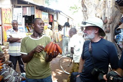
Alternatively, I was thinking of titling this post, “Restful Day and Red Bananas”, but I couldn’t help but throw a little literary allusion to my writing for the day 🙂 I’ve been alternating between thinking about blogging about several days at a time vs. one day at a time, and so far, the daily blog seems to be the way I’m going. Takes a lot longer, but there’s lots to talk about when it comes to a once-in-a-lifetime trip. This post is one of the few days where we didn’t really have much on tap. We were slated to visit a local village and do some shopping, and our base for the day was a really cool ‘permanent’ camp where there were tons of blue-balled monkeys running around. Yes, there is a very good reason that they are called that, and if you turn your attention to some of the pictures that were put up from the day, you’ll see why 🙂 As it turns out, this was also really the only chance we’d have at doing shopping for our Secret Santa. Read on for more.
Good news everybody. Today I can finally write about getting out of the safari vehicle and actually doing some real hiking. Mind you, I’m not talking about a multi-day challenging trudge or anything, but at least the dust in my nose would be from kicking at the dirt rather than by driving through it, so that’s something. Our first foray into the hills was a hike up Mount Lemagrut, which is one of 9 craters in the Ngorongoro conservation area. Although we’d be trekking up to 3100m this day, we were starting out at about 2400m, so the overall altitude gain and loss wasn’t going to be that great. This would however serve as our first acclimatization hike of sorts, and give us an idea how we might do as a group on the more challenging days ahead of us. This is also the first time I’ll be sharing a nice map of the trek with you all. As you might expect, I carried a GPS with me for most of the trip, and made a number of maps to show you where we went. Along with the map you can also head to flickr and check out the set of pictures and videos from the day. Once you’ve taken all that in and set the scene, come on back and read the rest of my tale!