16/02/08 to 18/02/08
Wow! Well, I’m back from another great weekend of tramping in the wilds of New Zealand. This time, I was tackling the Rees-Dart Track, as well as tacking on a full-day hike to the Cascade Saddle and back. Normally, they rate this as a 4-5 day tramp, but I was doing the whole thing including the Saddle side trip in 3 days. Perhaps that’ll give you an idea of why I took a day off when I got back. The third day was definitely killer, and took me 9 grueling hours of hiking to finish off. However, I’m getting a little ahead of myself, and I’m aiming to fill you all in on at least some of the details of those three glorious days. Read on for the details, and check out the maps (day 1, day 2, day 3) and the pictures (day 1, day 2, day 3). The day 3 map is highly abbreviated, as the batteries were dead fairly early that day. Oh well.
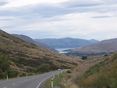
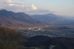
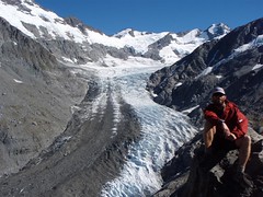
I’m calling this weekend trip an Adventure Challenge as I definitely felt like I was doing an adventure race at times. I even ended up naming some of my stops CPs and looking forward to the transition zones to do different things. The first leg of the challenge was actually in Queenstown, as I had to catch a ride from Q-Town up to Glenorchy, as well as find rides to get to the trailhead. I left in the late afternoon, hoping that someone would be headed that way for the weekend. My first ride was a couple of Swiss guys who were only going halfway to a lookout. All told, it was a pretty good place to stop, as the view was breath-taking. Unfortunately, I then had to walk quite a way before finally being picked up again for the rest of the way by a Macedonian jumpmaster who worked at a drop zone out in Glenorchy. He dropped me off at the holiday park, where I booked a bunk for the night. I ended my night by going to the local watering hole which was full of real kiwis drinking up and dabbling in karaoke. Wish I could’ve stayed longer there.
Next morning, it was back on the road trying to hitch the remaining 24km. Tougher than I expected, mainly because the gravel road leading to the trailhead has only traffic bound for the track which isn’t a really big one. Luckily, I did get a lift right to the start by a couple that were doing it that weekend as well. Sweet as bro! I slung on the ole backpack, and hit the dusty road. Well, actually, it was a boggy road. When they said ‘expect boggy conditions’, they should have said ‘bring your hip waders’. The Rees valley was a bit of a slog uphill, with many of the little creeks slightly swollen from the recent rainfall, and a lot of the ground soggy. The day’s hiking was about 20km, passing one hut along the way, and climbing over the Rees saddle, a cool climb up to a mountain pass where you get a good look at the valleys below and the mountains ahead. From the saddle, it was a marked route only to the Dart Hut where I was staying. The route was a cool one, with lots of exposed cliffs and tricky footing, just what I love. However, the scenery made this outstanding, with roaring rivers below, and mountains all around. What could be better.
Even though I had only left after 10am, I made it to the hut by around 5pm, so it took just under 7 hours for what was posted as a 10-14 hour trip. Cool. However, I was a little pooped from the trip, and looking forward to my supper. Unfortunately, I didn’t have a stove to cook anything, and had to bum a stove, pot, fuel, and utensils from a nice hut user. Luckily, there was one such user, and I got to eat a warm meal. This is a good thing, because otherwise, all I had to eat were trail mix, granola bars, some chocolate, energy bars and cheese and crackers. There were about a dozen or so other people staying at the hut, and it turned out that most of them were also planning to climb up the cascade saddle the next day, because the weather was looking like it would be fantastic. D’oh! In order to get a head start on the masses, I decided to head out early the next morning.
Well, early for me meant only 8am, but it was still early enough to be on the trail before anyone else, which really surprised me. Happily, since I’m also a bit quicker on the trails, I got to the top and had an hour up there all to myself. The weather was gorgeous, with no clouds, so I had most impressive views of the Dart Glacier, Mount Aspiring, the Matukituki Valley, and tons of other great sights. I ended up taking an 8 shot panoramic picture which will hopefully turn out nice. While up there, I chowed down on some delicious peanut M&Ms, and some trail mix while dangling my feet over the 1,000m cliffs. Yup, that’s how far I would’ve dropped. Almost a kilometer. Crazy, isn’t it? And they say bungy jumping is crazy!
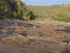
As it was still relatively early in the day, I thought about doing another side hike to a glacier, but it would’ve added an extra three hours onto the hike after getting back to the hut. Instead, I opted to explore the valley floor a little bit longer, and to check out the glacier snout a little bit, as well as some of the amazing waterfalls coming down from the hanging glaciers. As I was crossing the very wide glacier river area and craning my neck up skyward, it occurred to me that with the warm weather and beating sun, pieces of those hanging glaciers could actually come crashing down. Needless to say I was a little weary, and didn’t stick around there too long, especially when I saw some of the previous extra large chunks that had dropped down in the past. Yikes! I made my way back to Dart Hut, and rather than hiking further, I stripped down to my skivvies and had an alpine shower. Basically, I submerged my body in the glacier-fed river for a couple seconds to cool off and take a layer of sweat and sunscreen off. It was long enough. It took a little while for the radiant sun to heat me back up.
That night was a repeat of the night before, where I bummed a stove off someone to make my supper, and I loaded up on all the extra food that I could spare, to make my load lighter for the next day, which would be the longest hike that I took. I also met a girl hiking who came from Hawaii, and we played cards (speed) until the sun went down. Thank goodness for that, because otherwise, I’d basically just have been sitting around waiting for it to get dark. If you’ve ever done a multi-day tramp, you’ll know what I’m talking about. You’re too tired to do any hiking, and there’s very little else to do in a hut alone, so you just lay down, and wait for dark to sleep. I repacked my stuff in order to be able to hit the road before 8am the next day. I wanted to get a head start so that I could make it to the road end in time to hopefully catch a lift to Queenstown.
The third day of hiking started off quite well for me. I was on the trail by around 7:45am, and the weather was just right. It was cold, and a little overcast, so overheating wasn’t going to be a problem for quite some time. The trail was predominantly downhill, so my pace was pretty quick. However, as the time wore on, and I emerged into some grassy plains, the sun came out bright and strong, making things tougher. I felt pretty well hydrated, but at the end of the day, I realized that I hadn’t drank nearly enough. The scenery was more great mountains and valleys, mostly behind me now though, as the trail takes you out of the mountain range by following the Dart River. Again there were some cool creek crossings, and an even cooler rock bivy.
What’s a rock bivy you ask? Well, this was a really huge rock that had space under it for sleeping, and had obviously been in use for many decades on this track. There was a little windbreaking wall built up in front of it, and a cooking spot, and there must have been room for about 8-10 people to comfortably sleep in there sheltered from the elements when needed. Generally, it’s used in winter when the water is too high to cross a certain creek, but this day, I used it to take off a couple layers, eat a snack, and put on sunscreen. It was one of my only breaks of the day. The second came a couple hours later at the next official hut on the trail, where there was a helicopter. Not sure what it was doing there, but they didn’t pick me up when I tried hitch-hiking :-). Kinda wished they had, because from there to the end, it started to feel like more of a slog.
My pack was starting to feel heavy on my shoulders, and my stomach was telling me that it wanted something more substantial in it than granola bars. Sadly, I had nothing to offer it at the moment, so it would have to wait until Q-Town. Sadly, that was still some way away. This is when I really started treating the trek like an adventure race leg. I willed myself to keep moving fast, and ran all the downhill sections, and didn’t take breaks. Uphill I kept the pace very steady, and my timer reminded me to eat and drink periodically. I kept saying, “just make it to CP6/TA2, then you can take a longer break and recharge. That was at Chinaman’s Bluff, a parking lot at the end of the trail where I hoped to catch a lift.
When I did get to Chinaman’s, it was both a great feeling, and a little concerning. I was out, but there were no real cars that would be able to drive me that I could see. I paused long enough to fill up a water bottle, and to change into some dry socks and my ‘travel’ clothes instead of my spandex shorts and tank top. One car left with two people in it, but they ignored me completely. So, it was back on the road. I hiked, and hiked, and hiked some more. It was probably another 7 or so km before I finally got picked up by a guy who had passed me on his way in. He was just scoping the area out for the next day, and had room for me. Sweet. He took me all the way to Glenorchy, where I dropped off my intentions form (form to tell authorities you got out safe). Then, I bought a twix bar and a bottle of Powerade, and was back on the road. Happily, it was only about 6 minutes before a really friendly Kiwi fella picked me up and took me all the way back to Queenstown. I was totally exhausted, but very happy at my weekend tramp. However, I decided that rather than try to leave the next morning, I’d take a day off to recover, which is why you’re reading this and have all those pretty pictures to look at over on flickr!
If you ever get the chance to hike the Rees / Dart tracks, I’d definitely say go for it, but you might want to budget an extra day. If you don’t get the chance though, you can at least have a look at my pictures. Well, till next time, you stay classy world!