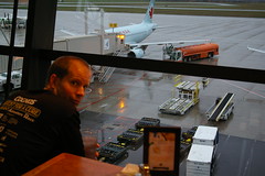
Sitting in Nate’s in the Ottawa airport waiting for flight.
Last Canadian meal before beef time!
Dreary weather is looking in on us from the outside world. Overcast and the like.
I’m peering out at a robin’s-egg blue Air Canada plane at gate 17. Ours is next to it.
C-GJWO is our equipment. Airbus 319. Looks air-worthy. We’ve got about 1:15 till lift-off 0:45 till we board.
Update: there was a gate change, we were actually at Gate 15. Don’t know what the tail ID was. Sorry kev.
You may also like
Okay friends and well-wishers, enough messing around with safaris and red bananas and lounging by a pool. It’s high time we got down the business of scaling some of the bigger peaks in Africa. This post will serve as the kick off for the first of our true hiking experiences during out African adventure. On tap first? Mount Meru, which at 4,566m high is Africa’s fifth highest peak. The purpose of us scaling this lesser peak first was primarily to assist us with acclimatization, as well as giving our lead guide for Mount Kilimanjaro a chance to see how we might perform when it came time to the big show. This climb would take us 4 days and 3 nights, although the only real climbing day would come starting at day 2 starting at midnight. On that day, we’d be going for the summit. However, before we get to that day, I’ll write a post for each of the days we spent on the mountain, but try not to make them too long ;-). Also, since we’re on a mountain now, I’ve got a map to share with you, as well as a set of pictures from the first day itself. Enjoy those, then click on back and read the rest of the story.
26/02/08
Good day to you all. Welcome to the Southernmost chapter in my Aotearoa Adventures. That’s New Zealand to most of you 🙂 Today I would like to tell you a little bit about my journey by car and boat to Steward Island, the Island off the south coast of the south island from Bluff. Yup, my main goal of this trip was to get all the way from the far north of New Zealand to the far south, and you can’t get much further than actually leaving the main island and getting onto one of the other smaller islands off the coast. Granted, there are islands much further south, but this was really the best I could do. Things got off to a bit of a shaky start for various reasons for the day, but eventually everything worked out, which it always seems to if you just relax and go with the flow. Check out my map, pictures, and of course read on for the gory details. Or at least some of the details. I’m going to try to be brief, as I find myself again 3 posts behind, which sucks when you’re me 🙂
Howdy folks. So, another day, and another 86km into the bike ride. Actually, it was a little more than 86km, since I went to the grocery store after finishing my day’s ride. I could’ve just had take-out again, but I decided it would be better to pick up some fresh fruits and veggies to munch on, along with the requisite pizza. However, I’m getting ahead of myself yet again, you’re probably more interested in what happened today anyway. I did in fact change my original plans of heading to the absolute north of the island by bike, and opted instead today to cut across the middle of the Island in order to reach the Bay of Islands, which are a beautiful part of New Zealand, and where I decided to spend at least two days. Read on.
27/01/08
Good day to you all! Although I’m pretty bagged at the moment, I think I’ll try to throw together my blog post right away, as I don’t think I’ll be any more awake tomorrow after a long day in the saddle with some big climbs to tackle. Today was a nice change for me. I spent the entire day paddling a kayak in the Abel Tasman National Park. And I do mean all day. I was up at 6am, and didn’t get back here until 7pm, just in time to go buy some delicious Chinese food for supper, and get to work on preparations for leaving Nelson after spending 3 nights here! I was blessed with yet another great day of weather here, although I fear that will soon grind to a halt by the look of both the sky and the forecast I just saw on the TV in the lounge here. Sounds like only light rain here though, not full-on showers as I was worried about. Anyway, read on for my post, and check out my map. The stats on it are just from the paddling and hiking, not the bus trip there and back.


