Daily archives: January 14, 2008

5 posts

Back to the Tasman Sea

15/01/08
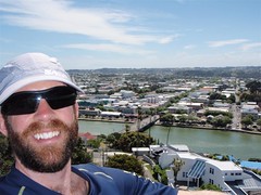
Hi gang! Wow, another day has gone by, can you believe it? I just heard that some of you are wondering where all the posts went. Well, don’t worry. As you can see, I’ve been keeping up with my end of the bargain, but the NZ Internet it not living up to its potential yet! Hee hee. At any rate, I, your humble scribe, am still hard at work. Both on the road and off the road, so I bring you yet another story in the life of ActiveSteve, even though you haven’t seen any for days on end 🙂 Today I was heading from Raukawa Fall, the YMCA camp, down to Wanganui, a shortish 60km ride taking me to the Tasman Sea, and closer on the route to the south Island. As mentioned earlier, I’ve booked a return bus trip to New Plymouth from here, in order that I may check out the Eastern Coast of the North Island, and Mount Taranaki in general. This is not in any sort of violation, as I’ll still be biking from north to south on my trip, but otherwise, I would have to spend at least 4 days (2 up, 2 back) just to check out that town, and I wasn’t about to do that. Anyway, read on for a little bit about today and Wanganui.

From High up to Down Low

14/01/08
Happy Monday to you all! As you’ve probably noticed, I was unable to post anything last night. This wasn’t because my hostel didn’t have the facilities, but rather because according to the manager there, the Internet was down all across New Zealand. That’s too bad, because I was hoping to get you caught up on my exploits. However, as I now find myself in essentially the middle of nowhere (Raukawa Falls), I still won’t be able to post anything. I have high hopes for tomorrow however, as I’ll be in a town of over 40,000, so surely they’ll have fixed the Internet there, right? Hee hee. Well in spite of that, my trip continues, and I have a new post to write for you all. Today Ralph and I bid farewell to Tongariro National Park, and made our way (mostly downhill) to the Raukawa Falls Adventure Centre, which is a YMCA camp, but also has cabins for independent travelers. We got a cabin for 15NZD each. Not bad. The location isn’t too shabby either, with some really cool falls nearby, as well as a flowing river behind our cabin. So, read on for my little story, and don’t forget to check out the day’s map. With the return of reliable power, I can give you an accurate map now 🙂

Ceiling of the North Island

13/01/08
Yeehaw! I did it! I reached the highest point in the North Island of New Zealand. Yup, Ralph and I achieved our goals yet again on another glorious day in Tongariro National Park. We managed to summit Mount Ruapehu, through the aid of both a car, and some chairlifts. Hows that you say? Well, the start point was 6km up the road, very much uphill, so we decided to hitch-hike up and back instead of biking. Also, rather than try to scale the entire vertical distance by foot, we took the park people’s advice and paid 20NZD for the chairlifts to take us up to 2000m, leaving us only an extra 700+m of vertical to climb. Our plan was to be on the first chair at 9am, and be back in Whakapapa Village around 1pm, and in National Park Village and the included spa by 3pm. Read on for a bit more of the day, and check out the map. Sadly, the GPS was paused at some point early in the climb, and I didn’t realize till much later, so a lot of the pictures are in the wrong place. Sorry, but that’s the best I can do for now.

Scaling Peaks in Sunshine

10/01/08 to 12/01/08
Good day to you all! Well, it’s been several days since I wrote a blog post, primarily because there was no way I was going to lug a computer around with me on the highest peaks of the North Island. Not that I’m not loyal to you all, it’s just that there wasn’t going to be any power anyway, and I really wanted to focus on the hiking and the sights. Let me tell you right off the bat, I was not disappointed in any way with my decision to spend 3 days in Tongariro National Park doing the Tongariro Northern Circuit with Ralph. I’m not sure how I can actually write a blog post that does any justice to my experiences in the past couple days. They are just so numerous and awe inspiring that it’s really one of those experiences you’d have to be there for. The pictures are probably the closest thing, and those will have to wait until I send a CD of the full-resolution pictures for Jody to post for everyone. It was just that good. In any case, you can for now check out two maps for days one and part of day two before the GPS batteries died. What follows are a few more of my thoughts on the experience, and what lies ahead for me.

On the Road to Mount Doom

09/01/08
Howdy winter folks! ActiveSteve here, reporting from Tongariro National Park. Today’s bike ride was more or less a highway to heaven sort of thing. It was a steady all day climb, where we started at 380m, and ended up at 1140m, in a little place called Whakapapa Village, which is near one of the busiest ski areas in the North Island. Of course, it being summer over here, the town is a little more deserted. Basically, anyone who is up here is here for one reason alone. To do some hiking in the National Park area. Were there not so many clouds hanging out right now, I’d have a pretty splendid view of Mount Tongariro and Mount Ngauruhoe. Not to mention Mount Ruapehu, the tallest of the lot. So, what’s up now you ask? Well, read on and I’ll spin you a little yarn.