
10/01/08 to 12/01/08
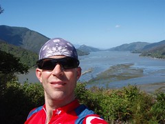
Good day to you all! Well, it’s been several days since I wrote a blog post, primarily because there was no way I was going to lug a computer around with me on the highest peaks of the North Island. Not that I’m not loyal to you all, it’s just that there wasn’t going to be any power anyway, and I really wanted to focus on the hiking and the sights. Let me tell you right off the bat, I was not disappointed in any way with my decision to spend 3 days in Tongariro National Park doing the Tongariro Northern Circuit with Ralph. I’m not sure how I can actually write a blog post that does any justice to my experiences in the past couple days. They are just so numerous and awe inspiring that it’s really one of those experiences you’d have to be there for. The pictures are probably the closest thing, and those will have to wait until I send a CD of the full-resolution pictures for Jody to post for everyone. It was just that good. In any case, you can for now check out two maps for days one and part of day two before the GPS batteries died. What follows are a few more of my thoughts on the experience, and what lies ahead for me.
As mentioned, the GPS batteries obviously didn’t last the entire 3 days. They usually only last about 12 hours, so I knew I wouldn’t have a complete map. However, the most important bits were covered, and I have plenty of pictures from all 3 days to share, so there are lots of media forthcoming. From my Suunto watch, here are a few of the statistics of the days, basically, time spent hiking / climbing, and the ascent and descents.
Day 1: 6h 55m, Ascend: 1131m, Descend: 945m, Max: 1436m, Min: 1082m.
Day 2: 7h 13m, Ascend: 1706m, Descend: 1628m, Max: 2226m, Min: 1324m.
Day 3: 5h 05m, Ascend: 786m, Descend: 1112m, Max: 1867m, Min: 1070m.
Of course, those are just numbers. What do they all mean? Well, for starters, my legs currently feel like I ran a marathon. For an example of the foolishness, today was supposed to take a regular hiker about 8 or 9 hours. We did it in 5 hours! Does that give you an idea? We were going at a very quick clip to say the least. This doesn’t mean that we weren’t taking the time to enjoy it, we were just hiking pretty quick and playing fast and loose with some technical descents. We were in our element and having a great time. Such a great time in fact, that we’ve decided that tomorrow we’re going to hopefully summit the highest peak on the North Island before heading out on our bikes for the next town. Yup, next stop, Mount Ruapehu at 2795m. We’re currently at 1136m. It’s completely doable, especially by taking the chairlift to 2000m. Wish us luck. But now, about the Northern Circuit.
The main trail takes you around and through the peaks of Mount Ngauruhoe and Mount Tongariro. During the circuit, we pass through many different ecosystems, from desert like scapes, to forests, to tussock fields, as well as lots of volcanic geography. As you may know, Lord of the Rings used the places nearby as the Plains of Gorgoroth, Mount Doom, Mordor, and Ithilien. The scenery definitely did not disappoint. The other two days of trekking, we pressed equally hard in order to do all the main trails, as well as do several of the side trips such as Upper and Lower Tama lakes, which are volcano crater lakes, Taranaki Falls, a beautiful waterfall area, an old historic hut, as well as Soda Springs, a mountain spring. Oh yeah, that and scale the sheer sides of Mount Ngauruhoe and the rocky path to the summit of Mount Tongariro.
Another highlight of this tramp was getting to experience the pseudo famous Kiwi hut system. Basically, we bought a pass each for 2 nights’ accommodation in huts, which are bunk houses. You don’t make reservations or anything. It’s first come first served, and you cram as many people in as you can. Our first night was at Oturere Hut, normally a quiet hut. There are beds for 26. Well, about 40 showed up!!! Needless to say, it was very cosy, with bodies strewn all over the floor and even the front porch, as well as others in tents. Luckily, the second night, our hut only had 10 people for 22 beds, so we all had lots of room. There is no rhyme or reason to how busy a hut will be. Ralph and I were fortunate enough to get bunks both nights, since in spite of pushing hard each day, we were done by 3ish both days. This was to give ourselves time to cook a half-decent meal, and get to bed early so that we could get hiking by the early morning light. Who’d have thunk I’d be up before 6am, and on the trails by 6:30 of my own volition, eh?
Clearly, the big day for us was day 2, when we decided we do both of the summits. We were up early, pushing hard to beat any possible crowds to Mount Ngauruhoe. Now, most people don’t actually climb it, as the sides are very steep, and it’s a straight push directly up a massive scree slops, except for a few rock bands to scramble up. The sight of it is very daunting, and we had out doubts, but as you get on it, and start pushing, before you know it, you’re high above the dome floor. Looking up and down, it’s mighty impressive. But the view from the top is outta sight. This is an active volcano kids, so there is steam coming up from the top, and a massive crater at the top. We did a crater walk, and had spectacular views all around. Although the climb usually takes 2 hours, we made it in 1 hour. Oh, and the descent? Well, let’s just say my 15 minute descent was the stuff of legends 😉 I plowed full bore into the scree and slid / skied all the way to solid ground. It was an amazing rush unparalleled by activities you have to pay for!
The pictures from the top show you the snow line as well, and where we slid on the snow as part of the descent. However, once at the bottom, it wasn’t time to rest. Nope, we had another peak to tackle. Mount Tongariro. This climb was a more classic climb, basically following a well-worn trail to the top. After Mount Doom, this one didn’t have quite as good a vantage, but was still a cool feeling. We snacked and stayed up there for about 10 minutes, before getting back to the work of descending to our second hut, Ketetahi, which is located by a thermal springs area, and is directly in a danger zone for volcanic activity. Cool. At that hut, there was a radio, and that was where I first heard that Sir Edmund Hillary, a Kiwi legend, and the first person to summit Everest, had died that day. When? Well, about the time that we were summiting Mount Ngauruhoe. That left me with some pretty powerful feelings as well. Here I was, perched 1400m above sea level, looking out at an amazing vista, after a day of claiming 2 summits, when a man like Hillary passed away. I immediately declared that the tramp for the next day would be in Sir Ed’s memory. This was met with agreement by several other hikers, and approval from Kiwis as being a noble thing.
That night was a very nice sleep, and getting up this morning, Ralph and I had a fire under our butts. To start the day, we had a long climb back up to the main part of the Tongariro Crossing, then had to do the entire crossing in the opposite direction as the flow of traffic. As this was Saturday, and a beautiful day, the crowds were amazingly thick, even early. At one spot, called the Devil’s Staircase, we were leaping and bounding down hundreds of meters of lava boulders, dodging tourists left and right. It was incredibly thrilling, but is the dominant reason our calves are killing us today. In 3 short hours, we’d covered the distance from Ketetahi Hut to the head of the Tongariro Crossing, which is pretty much a whole day hike for some. All that was left was the final tramp from Mangetepopo Hut to Whakapapa Village. The signs warned of this taking 5 hours in bad weather.
This was yet another completely different terrain. We had tussock grass up to our armpits, and lots of other vegetation crowding all around us, as we followed a trail that was as much a ravine / ditch as it was a path. There were countless river crossings, all dry for us. We could easily see how this would be a nightmare in bad weather. I guess the whole thing basically becomes a swampy wasteland with raging rivers interspersed. However, once again the gods of the mountains were with us, and in spite of having clouds, we had a great trek. We capped the whole thing off by having fries and a beer at the closest cafe to the end point, which had opened only 20 minutes before we arrived, just before noon!
Whew! What a rush. I know I’m forgetting to tell you about a million things, but there’s just so much floating around in my head. Like Alpine Showers, which is the light cleaning we’d do each night with freezing stream water. Or how about the loud, annoying, snoring fellow in the first cabin who was rude and hogged mattresses? Or what about the first sight we had which was Taranaki Falls. Or even upper and Lower Tama lakes, which were each spectacular places with generous views of the surrounding peaks to share with us. Or what about Red Crater, the absolute coolest thing I think I saw, with a really neat fissure. Oh boy, there’s just so much. I’m too excited and overwhelmed. Oh yeah, and tired. It’s almost 9pm, and I’ve done the maps, and titled all the pictures, but I have to get some sleep to prepare for Mount Ruapehu, the next adventure.
So, what’s next, you ask? Well, I’ve got the bug, and have decided to take a bit of a fast forward. I’m going to head south from here to Wanganui, but then probably take a bus to New Plymouth, which is by Mount Taranaki, the second highest peak in the North Island. I’ve decided it must be mine as well 🙂 I’m still doing well with time, and I’ll still make South Island before February. That way, on the way back, I can loop up the East Coast of the North Island to see Napier / Hastings, and other places I’m told are nice. South Island is getting closer, but I’ve made no firm plans there yet, although I’ve met many people with ideas on what to do while there.
And what of Ralph and I? Well, we’ll be together till at least Wanganui I think, at which point we’ll probably part ways. We’ve made fairly agreeable travel partners, but as with most solo travelers, we do each have our own paces, and at some point, we have to go our own ways and forge our own paths. It’s been a lot of fun, and we got along superbly during the tramping. It was certainly fun to have someone who wanted to push like I did on the hiking, and shares a similar world view. Well, that’s it for me for now. I hope you’ve enjoyed my rambling, jumbled thoughts on the Tongariro Northern Circuit, and if you’re ever down this way and have a few days, I highly recommend it. It helps that I had great weather though :-). Hope you’re all doing well, and stay tuned for more from ActiveSteve as time permits.