You may also like
Howdy folks! While the sun may be shining, and thoughts are definitely fully turned to summer training and adventures, now is as […]
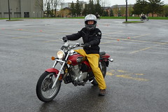
Hello adventure-loving friends. I have a really short and sweet blog post for you all. Between training, racing, and general fun-having with Deanna, it’s a wonder I ever find any time to try new things around here. However, much like trying my hand at snowboarding this winter, I have also decided it was high time to pick up a new summer activity as well. Any guesses? Well, I suppose the picture sort of spoils the surprise, doesn’t it? Yup! Motorcycle riding! The idea has been percolating in my noggin for some years now, but upon learning Deanna was also keen on the idea, we went ahead and pulled the trigger on this new pursuit. And as with all my activities, I don’t just dip my toe in the water, I dive right in. Before the snow had even fully melted, I had a helmet, jacket, gloves, and even secured my first motorcycle! All without even knowing how to ride a motorbike. For some pictures of my new ride, as well as some shots of me in training, head over to my flickr folder. Then, read on for a very brief summary of the process of getting my licence in Quebec, and where I’m at.
Click here for pictures from Salta. Geez, I totally forgot to mention. So, on the great football game day, not only did our team win, but Air Canada scored a small victory. When we returned to the hotel, the missing bag had shown up! If it could write a blog, I’m sure it would be interesting, but sadly, we can only ever guess at the route it took to get back to us. But it did. Fully intact. Huzzah, vacation angst spared. One more thing to note, if heading to a football match, shirts are 30pesos before the game. Afterwards, you can score the same one for 20 pesos (7 bucks), so I’m now sitting in my ‘away’ jersey for river, a nice adidas tech shirt (well, let’s be honest, Adidas has no idea this shirt exists, hence adidas with the lower case a).
Well, here I am, blogging to you live from the very boring LAX Terminal 2 lounge. The time here is 19:21, which is already 22:21 your time. I left for the airport in Ottawa quite a while ago already, yet have many more miles to journey before I get to Nadi, Fiji. My flight leaves here at 22:15, and it’ll be after 6am on Wednesday before I finally reach my final destination. To get there, I travelled west only. You know what the funny thing is? Well, to get to LA, I’ve travelled “back” in time 3 hours, but ther further I fly west, I’ll eventually flip forward in time, landing on the other side of the international date line. Weird stuff, isn’t it? Let’s flip back to earlier today, and you can catch up to my journey thus far.


